TED日本語
TED Talks(英語 日本語字幕付き動画)
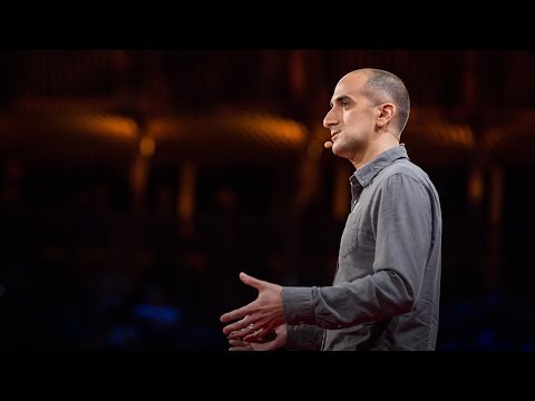
TED日本語 - エリック・サンダーソン: ニューヨークが都市になる前の景観
TED Talks
ニューヨークが都市になる前の景観
Eric Sanderson pictures New York's natural history
エリック・サンダーソン
内容
ハドソンがニューヨーク湾を発見してから400年後、エリック・サンダーソンが、マンナハッタが都市になる前の、山々や川、野生動物に満ちた素晴らしい生態系の立体地図を作った模様を紹介します。その当時、タイムズスクエアは湿地帯で、配達を受ける事も出来ませんでした。


字幕
SCRIPT
Script

The substance of things unseen. Cities, past and future. In Oxford, perhaps we can use Lewis Carroll and look in the looking glass that is New York City to try and see our true selves, or perhaps pass through to another world. Or, in the words of F. Scott Fitzgerald, "As the moon rose higher, the inessential houses began to melt away until gradually I became aware of the old island here that once flowered for Dutch sailors' eyes, a fresh green breast of the new world."
My colleagues and I have been working for 10 years to rediscover this lost world in a project we call The Mannahatta Project. We're trying to discover what Henry Hudson would have seen on the afternoon of September 12th,1609, when he sailed into New York harbor. And I'd like to tell you the story in three acts, and if I have time still, an epilogue.
So, Act I: A Map Found. So, I didn't grow up in New York. I grew up out west in the Sierra Nevada Mountains, like you see here, in the Red Rock Canyon. And from these early experiences as a child I learned to love landscapes. And so when it became time for me to do my graduate studies, I studied this emerging field of landscape ecology. Landscape ecology concerns itself with how the stream and the meadow and the forest and the cliffs make habitats for plants and animals. This experience and this training lead me to get a wonderful job with the Wildlife Conservation Society, which works to save wildlife and wild places all over the world. And over the last decade, I traveled to over 40 countries to see jaguars and bears and elephants and tigers and rhinos.
But every time I would return from my trips I'd return back to New York City. And on my weekends I would go up, just like all the other tourists, to the top of the Empire State Building, and I'd look down on this landscape, on these ecosystems, and I'd wonder, "How does this landscape work to make habitat for plants and animals? How does it work to make habitat for animals like me?" I'd go to Times Square and I'd look at the amazing ladies on the wall, and wonder why nobody is looking at the historical figures just behind them. I'd go to Central Park and see the rolling topography of Central Park come up against the abrupt and sheer topography of midtown Manhattan.
I started reading about the history and the geography in New York City. I read that New York City was the first mega-city, a city of 10 million people or more, in 1950. I started seeing paintings like this. For those of you who are from New York, this is 125th street under the West Side Highway. (Laughter) It was once a beach. And this painting has John James Audubon, the painter, sitting on the rock. And it's looking up on the wooded heights of Washington Heights to Jeffrey's Hook, where the George Washington Bridge goes across today.
Or this painting, from the 1740s, from Greenwich Village. Those are two students at King's College -- later Columbia University -- sitting on a hill, overlooking a valley. And so I'd go down to Greenwich Village and I'd look for this hill, and I couldn't find it. And I couldn't find that palm tree. What's that palm tree doing there? (Laughter)
So, it was in the course of these investigations that I ran into a map. And it's this map you see here. It's held in a geographic information system which allows me to zoom in. This map isn't from Hudson's time, but from the American Revolution,170 years later, made by British military cartographers during the occupation of New York City. And it's a remarkable map. It's in the National Archives here in Kew. And it's 10 feet long and three and a half feet wide.
And if I zoom in to lower Manhattan you can see the extent of New York City as it was, right at the end of the American Revolution. Here's Bowling Green. And here's Broadway. And this is City Hall Park. So the city basically extended to City Hall Park. And just beyond it you can see features that have vanished, things that have disappeared. This is the Collect Pond, which was the fresh water source for New York City for its first 200 years, and for the Native Americans for thousands of years before that. You can see the Lispenard Meadows draining down through here, through what is TriBeCa now, and the beaches that come up from the Battery, all the way to 42nd St.
This map was made for military reasons. They're mapping the roads, the buildings, these fortifications that they built. But they're also mapping things of ecological interest, also military interest: the hills, the marshes, the streams. This is Richmond Hill, and Minetta Water, which used to run its way through Greenwich Village. Or the swamp at Gramercy Park, right here. Or Murray Hill. And this is the Murrays' house on Murray Hill,200 years ago. Here is Times Square, the two streams that came together to make a wetland in Times Square, as it was at the end of the American Revolution.
So I saw this remarkable map in a book. And I thought to myself, "You know, if I could georeference this map, if I could place this map in the grid of the city today, I could find these lost features of the city, in the block-by-block geography that people know, the geography of where people go to work, and where they go to live, and where they like to eat." So, after some work we were able to georeference it, which allows us to put the modern streets on the city, and the buildings, and the open spaces, so that we can zoom in to where the Collect Pond is. We can digitize the Collect Pond and the streams, and see where they actually are in the geography of the city today. So this is fun for finding where things are relative to the old topography.
But I had another idea about this map. If we take away the streets, and if we take away the buildings, and if we take away the open spaces, then we could take this map. If we pull off the 18th century features we could drive it back in time. We could drive it back to its ecological fundamentals: to the hills, to the streams, to the basic hydrology and shoreline, to the beaches, the basic aspects that make the ecological landscape.
Then, if we added maps like the geology, the bedrock geology, and the surface geology, what the glaciers leave, if we make the soil map, with the 17 soil classes, that are defined by the National Conservation Service, if we make a digital elevation model of the topography that tells us how high the hills were, then we can calculate the slopes. We can calculate the aspect. We can calculate the winter wind exposure -- so, which way the winter winds blow across the landscape. The white areas on this map are the places protected from the winter winds.
We compiled all the information about where the Native Americans were, the Lenape. And we built a probability map about where they might have been. So, the red areas on this map indicate the places that are best for human sustainability on Manhattan, places that are close to water, places that are near the harbor to fish, places protected from the winter winds. We know that there was a Lenape settlement down here by the Collect Pond. And we knew that they planted a kind of horticulture, that they grew these beautiful gardens of corn, beans, and squash, the "Three Sisters" garden.
So, we built a model that explains where those fields might have been. And the old fields, the successional fields that go. And we might think of these as abandoned. But, in fact, they're grassland habitats for grassland birds and plants. And they have become successional shrub lands, and these then mix in to a map of all the ecological communities. And it turns out that Manhattan had 55 different ecosystem types. You can think of these as neighborhoods, as distinctive as TriBeCa and the Upper East Side and Inwood -- that these are the forest and the wetlands and the marine communities, the beaches.
And 55 is a lot. On a per-area basis, Manhattan had more ecological communities per acre than Yosemite does, than Yellowstone, than Amboseli. It was really an extraordinary landscape that was capable of supporting an extraordinary biodiversity.
So, Act II: A Home Reconstructed. So, we studied the fish and the frogs and the birds and the bees, the 85 different kinds of fish that were on Manhattan, the Heath hens, the species that aren't there anymore, the beavers on all the streams, the black bears, and the Native Americans, to study how they used and thought about their landscape. We wanted to try and map these. And to do that what we did was we mapped their habitat needs.
Where do they get their food? Where do they get their water? Where do they get their shelter? Where do they get their reproductive resources? To an ecologist, the intersection of these is habitat, but to most people, the intersection of these is their home. So, we would read in field guides, the standard field guides that maybe you have on your shelves, you know, what beavers need is "A slowly meandering stream with aspen trees and alders and willows, near the water." That's the best thing for a beaver.
So we just started making a list. Here is the beaver. And here is the stream, and the aspen and the alder and the willow. As if these were the maps that we would need to predict where you would find the beaver. Or the bog turtle, needing wet meadows and insects and sunny places. Or the bobcat, needing rabbits and beavers and den sites. And rapidly we started to realize that beavers can be something that a bobcat needs. But a beaver also needs things. And that having it on either side means that we can link it together, that we can create the network of the habitat relationships for these species.
Moreover, we realized that you can start out as being a beaver specialist, but you can look up what an aspen needs. An aspen needs fire and dry soils. And you can look at what a wet meadow needs. And it need beavers to create the wetlands, and maybe some other things. But you can also talk about sunny places. So, what does a sunny place need? Not habitat per se. But what are the conditions that make it possible? Or fire. Or dry soils. And that you can put these on a grid that's 1,000 columns long across the top and 1,000 rows down the other way. And then we can visualize this data like a network, like a social network.
And this is the network of all the habitat relationships of all the plants and animals on Manhattan, and everything they needed, going back to the geology, going back to time and space at the very core of the web. We call this the Muir Web. And if you zoom in on it it looks like this. Each point is a different species or a different stream or a different soil type. And those little gray lines are the connections that connect them together. They are the connections that actually make nature resilient. And the structure of this is what makes nature work, seen with all its parts. We call these Muir Webs after the Scottish-American naturalist John Muir, who said, "When we try to pick out anything by itself, we find that it's bound fast by a thousand invisible cords that can not be broken, to everything in the universe."
So then we took the Muir webs and we took them back to the maps. So if we wanted to go between 85th and 86th, and Lex and Third, maybe there was a stream in that block. And these would be the kind of trees that might have been there, and the flowers and the lichens and the mosses, the butterflies, the fish in the stream, the birds in the trees. Maybe a timber rattlesnake lived there. And perhaps a black bear walked by. And maybe Native Americans were there. And then we took this data.
You can see this for yourself on our website. You can zoom into any block on Manhattan, and see what might have been there 400 years ago. And we used it to try and reveal a landscape here in Act III. We used the tools they use in Hollywood to make these fantastic landscapes that we all see in the movies.
And we tried to use it to visualize Third Avenue. So we would take the landscape and we would build up the topography. We'd lay on top of that the soils and the waters, and illuminate the landscape. We would lay on top of that the map of the ecological communities. And feed into that the map of the species. So that we would actually take a photograph, flying above Times Square, looking toward the Hudson River, waiting for Hudson to come. Using this technology, we can make these fantastic georeferenced views. We can basically take a picture out of any window on Manhattan and see what that landscape looked like 400 years ago.
This is the view from the East River, looking up Murray Hill at where the United Nations is today. This is the view looking down the Hudson River, with Manhattan on the left, and New Jersey out on the right, looking out toward the Atlantic Ocean. This is the view over Times Square, with the beaver pond there, looking out toward the east. So we can see the Collect Pond, and Lispenard Marshes back behind. We can see the fields that the Native Americans made. And we can see this in the geography of the city today. So when you're watching "Law and Order," and the lawyers walk up the steps they could have walked back down those steps of the New York Court House, right into the Collect Pond,400 years ago.
So these images are the work of my friend and colleague, Mark Boyer, who is here in the audience today. And I'd just like, if you would give him a hand, to call out for his fine work. (Applause)
There is such power in bringing science and visualization together, that we can create images like this, perhaps looking on either side of a looking glass. And even though I've only had a brief time to speak, I hope you appreciate that Mannahatta was a very special place. The place that you see here on the left side was interconnected. It was based on this diversity. It had this resilience that is what we need in our modern world.
But I wouldn't have you think that I don't like the place on the right, which I quite do. I've come to love the city and its kind of diversity, and its resilience, and its dependence on density and how we're connected together. In fact, that I see them as reflections of each other, much as Lewis Carroll did in "Through the Looking Glass." We can compare these two and hold them in our minds at the same time, that they really are the same place, that there is no way that cities can escape from nature. And I think this is what we're learning about building cities in the future.
So if you'll allow me a brief epilogue, not about the past, but about 400 years from now, what we're realizing is that cities are habitats for people, and need to supply what people need: a sense of home, food, water, shelter, reproductive resources, and a sense of meaning. This is the particular additional habitat requirement of humanity. And so many of the talks here at TED are about meaning, about bringing meaning to our lives in all kinds of different ways, through technology, through art, through science, so much so that I think we focus so much on that side of our lives, that we haven't given enough attention to the food and the water and the shelter, and what we need to raise the kids.
So, how can we envision the city of the future? Well, what if we go to Madison Square Park, and we imagine it without all the cars, and bicycles instead and large forests, and streams instead of sewers and storm drains? What if we imagined the Upper East Side with green roofs, and streams winding through the city, and windmills supplying the power we need? Or if we imagine the New York City metropolitan area, currently home to 12 million people, but 12 million people in the future, perhaps living at the density of Manhattan, in only 36 percent of the area, with the areas in between covered by farmland, covered by wetlands, covered by the marshes we need.
This is the kind of future I think we need, is a future that has the same diversity and abundance and dynamism of Manhattan, but that learns from the sustainability of the past, of the ecology, the original ecology, of nature with all its parts. Thank you very much. (Applause)
物事の目に見えぬ本質 過去の都市 未来の都市 ここオックスフォードで ルイス・キャロルを引用して 鏡に映ったニューヨーク市を見てみましょう そして私たちの本当の姿を見つけるのです もしくは別の世界へと行ってみましょう スコット・フィッツジェラルドの言葉を借りれば “月が高く昇るにつれ 街並みは溶けて消えていった 心に浮かんだのは かつての島 オランダ人の船乗りの目を楽しませた 新世界の新緑の胸中だった"
私と同僚はこの失われた世界を 再発見する仕事に10年間取り組んできました マンナハッタ・プロジェクトと呼ぶプロジェクトです 私たちはヘンリー・ハドソンが 1609年9月12日の午後ニューヨーク湾に 到着した際に見たものを再現しようとしています 3幕の物語を語りましょう そして時間があればエピローグも
では第一幕 “発見された地図” 私はニューヨーク出身ではありません 出身地は西部のシエラネバダ山脈 ここにあるレッドロックキャニオンです またそういった幼少期の体験から 私は風景が大好きになりました 大学院で研究する頃になると 私は新しい学問領域の景観生態学を専攻しました 景観生態学は 川の流れ 草原 森 崖がいかに動植物の生息地を 形成するか探究します この経験や訓練のおかげで 私は野生生物保護協会の仕事に就きました 協会は世界中で野生生物や環境保護活動をします そしてここ10年間で 私は40以上の国々を旅し ジャガー 熊 象 虎 サイを観察しました
しかし旅が終われば いつもニューヨークに戻り そして週末には他の旅行者と同じように エンパイアステートビルの展望台に上がり この風景と生態系を見下ろしながら 疑問に思いました "この風景から どうすれば動植物の生息地が見えるだろう? 私みたいな動物の棲み家はどう作られるのだろう?" タイムズスクエアに行き 美しい女性たちの広告を見ながら 何故誰も背後にある歴史上の姿を見ようとしないのか不思議でした またセントラルパークによく行っては ミッドタウンの 険しく切り立ったビル群と 対照的な公園の穏やかな地形を眺めたものでした
私はニューヨークの歴史や地理を読み始めました ニューヨークは1950年に人口一千万人を超えた 初の大都市だった事を知りました またこのような絵画も鑑賞しました ニューヨーク出身の皆さん これはウェストサイドハイウェイ下の125番通りです (笑) そこはかつて浜辺でした またこの絵画では 画家のジョン・ジェイムズ・オードゥボンが岩の上に座っています そして木の茂るワシントンハイツの山並と 現在ジョージワシントン橋が掛かっているジェフリーズフックが描かれています
またこの絵画は1740年頃のグリニッチビレッジです 彼らはキングズカレッジ ― 後のコロンビア大学の学生で 谷を見下ろす丘の上に座っています 私はグリニッチビレッジへ行ってこの丘を探しましたが ありませんでした あのヤシの木も ヤシの木はどうなったのでしょう? (笑)
そして調査が進むと私はある地図を見つけました これがその地図です これは地理情報システムの一部であり 拡大表示ができます これはハドソンの時代ではありません 170年後 アメリカ独立革命時にニューヨークを占領した イギリス軍の地図製作者による物です これは驚くべき地図で キューの国立公文書館に保管されています 縦3m 横1mの大きさです
ロアー・マンハッタンを拡大すると まさに独立戦争が終結した頃の ニューヨークを見る事ができます ここがボウリンググリーン ここがブロードウェイです シティーホールパークです シティーホールパークまでが主な市街地でした そしてその向こうに見える地形は 消え去った 失くなった姿です これはコレクトポンドです ここはニューヨークの最初200年間と それ以前は数千年間先住民の 水源となっていました リスペナード草原が 今日のトライベッカへ広がっています また浜辺がバッテリーから 42番通りまで続いています
この地図は軍事目的で作成されました 建設された道路 建物 城塞が 描かれています しかし彼らは軍事目的以外に 生態学的にも興味がある 丘 沼地 小川を描いています これはリッチモンドヒルとミネッタ川 かつて グリニッチビレッジを流れていました グラマシーパークの湿地はここにあります マリーヒル そしてこれは200年前の マリーヒルにあるマリーの家です これはタイムズスクエアです 独立戦争終了時のタイムズスクエアには 二つの小川が集まり湿地帯を形成していました
私はこの驚くべき地図を本で見て 考えました “もし この地図を測位できたなら もし今日の街の地形上に描くことができたなら 私達の知る ブロック状に仕切られた 人々が働き 住み 食事をする場所に重ね合わせて 人々が働き 住み 食事をする場所に重ね合わせて 失われたこの土地の特徴を 再現できるかも知れない” と そして苦労して測位が完了しました その結果 この都市の現在の街路 建物 広場などを描くことができました こうしてコレクトポンドにズームできます コレクトポンドと小川をデジタル表示できます そして現在の街の地形上どこにあったのか再現できます かつての地形が 現在どうなっているのか 探すのは楽しいものです
しかし私には他の考えもありました 私達がこの通りを取り除き 建物を取り除き そして広場を取り除くと こうなります 18世紀の特徴を取り除くと 時間を遡れます 私達は生態学的本質である 丘 小川 基本的な水文学 海岸線 浜辺など 生態学的景観の基本的な特徴を取り出せます
次に地質学的岩盤 氷河が残した表層地質を重ね合わせ 米国土壌保全局が定義する 17種に分類された土壌分類地図を描き 17種に分類された土壌分類地図を描き 更に丘の高さを示す デジタル標高モデルを描くと 土地の傾斜を算出できます 外観を計算表示できるのです 冬の風向きと風速 どう風が吹くか計算できます 地図上のこの白いエリアは冬風が当たらない場所です
私達はデラウェア先住民族の居住情報を全て収集し 彼らが生活していたと想定される場所を地図にしました 地図上の赤いエリアで示すのは 最も持続可能な生活の場所です 水場に近く 魚を取れる湾岸に近く 冬風が当たらない場所です コレクトポンド周辺にデラウェア族の 居住地があったことが分かっています また彼らは園芸を行い トウモロコシ 豆 ウリの 3大農作物を 育てる美しい菜園がありました
そこで私達は その菜園があった場所を推定しました かつての地続きの土地です 放棄された土地と思うかもしれません しかし実際には草原で 鳥や植物の生息地でした 草原は潅木地帯につながっていました それらが組み合わされて生態系全体ができました マンハッタンには55の異なる生態系があったことが分っています これらは いわば隣町同士で トライベッカ アッパーイーストサイド インウッドのように独自の特徴を持っていました 森があり湿地帯があり また海洋の共同体であり浜辺です
55は非常に大きな数字です 単位面積あたりマンハッタンは ヨセミテ イエローストーン アンボセリよりも豊かな生態系だったのです 並外れた生物多様性を支える事ができた実に驚くべき景観だったのです 並外れた生物多様性を支える事ができた実に驚くべき景観だったのです
それでは第二幕 “再建された故郷” 私達は魚 カエル 鳥 蜂を調査しました 85種類の魚がマンハッタンに生息していました 既に絶滅したヒースヘンという鳥や あらゆる小川に生息したビーバー クロクマ 先住民族がいかに景観を利用し 何を考えていたのか学ぼうとしました 私達はそれらを表現しようとしました 生息環境要件のマッピングを試しました
彼らはどこで食料を得ていたのか? 水は?棲み家は? 循環資源は? 生態学者にとってはこれらの交差点が生息地です 一般人にとってはこれらの交差点が自分の家です いわば暮らしの手帳です どこの家庭にでもある手帳です ビーバーが必要とするのは “ポプラ ハンの木 柳が近くに茂る ゆったりと流れる小川” それがビーバーにとって最高の場所です
そこで私達はリストを作りはじめました これはビーバーです そしてこれが小川 ポプラ ハンの木 柳です まるで私達がビーバーを見つけるのを 予測するのに役立つ項目です モリイシガメに必要なのは 湿った草地 昆虫 日のあたる場所 です ボブキャットに必要なのは うさぎ ビーバー 洞穴のある場所 です すると突然 私達はボブキャットにはビーバーが必要なことに気付きました すると突然 私達はボブキャットにはビーバーが必要なことに気付きました しかしビーバーにもニーズがあります それらのニーズを関連づけると これらの種の生態系の 関連図を作ることができるのです
ビーバーの専門家から出発して ポプラのニーズを知ることが 可能な事にも気付きました ポプラに必要なのは 火 乾いた土壌 です また湿原のニーズを知ることもできます 湿地帯を作り出すためは ビーバーと 他に幾つかの物が必要です また日当たりの良い場所も語れます 日当たりの良い場所には生息地に限らず 何が必要でしょうか? どんな条件が揃えば良いのでしょうか? 火の場合は? 乾燥した土壌は? これらを縦横千個からなる表の上に 整理して表現できます そしてデータをソーシャル・ネットワークのように 視覚化できます
これはマンハッタンに生息した動植物の お互いのニーズを示す 全ての相関ネットワーク図で 地質学的に 時間的に空間的に中核まで遡っています ミューア・ウェブと呼びます 拡大するとこうなります それぞれの点が異なる種 あるいは水の流れ 土壌分類を示しています 細い灰色の線はそれらの要素を結びつけます それらの線は自然の弾力性を生み出しています 全ての構成要素からなるこの構造により 自然が機能するのです スコットランド系アメリカ人博物学者ジョン・ミューアにちなんだ名前です ミューア曰く “何かを単独で選ぼうとすると その物は目に見えない千の紐でしっかり 結ばれていて解くこともできず宇宙のすべてにつながっている”
私達はミューア・ウェブを地図上に展開しました 例えば 85番通り 86番通り レキシントン街 三番街に囲まれたブロックに行くと かつて小川があり 木々があり 花々 地衣類 コケ類や 蝶 小川には魚が 木々には鳥が生息していたでしょう ガラガラヘビも居たかもしれません クロクマが歩き周り 先住民族も居ました このようにデータを用いました
私達のウェブサイトでご覧になれます マンハッタンのあらゆるブロックを拡大し 400年前そこに何があったか見ることができます そうやって見える景観が 第三幕です 私達はハリウッドと同じツールを使い 映画でみるような素晴らしい景観を作りました
三番街を視覚化してみました まず景観の地形を描きます その上に土壌 水 そして景観を投影します そして 生態系を描きます さらに生物種を投影します タイムズスクエアからハドソン川を見て 探検家ハドソンの到着を待つ景色を 実写したかのような映像です 最新技術のおかげで 私達は このような素晴らしい昔の地形を再現できます マンハッタン中のどのビルの窓からでも 400年前の景観を見ることができるのです
イーストリバーからの眺め マリーヒルを見上げています 現在 国連本部がある場所です ハドソン川を見下ろしています 左がマンハッタン 右がニュージャージー 背後に広がるのは大西洋です タイムズスクエアです ビーバーの池が見えます 東を見渡しています コレクトポンド リスペナードが遠くにあります 先住民族が耕した畑が見えます 現在の都市の地形にも見ることができます 例えばドラマの"法と秩序"のなかで弁護士が ニューヨーク裁判所の階段を下りていくと 400年前なら コレクトポンドの湖面がありました
これらの映像は私の友人で同僚のマーク・ボイヤーが 制作しました 今日会場に来ています 彼の素晴らしい仕事を みなさんも一緒に讃えましょう (拍手)
科学と視覚化のコラボは大きな力となり 鏡の両面を見るかのような 映像を創り上げることができます 短い時間でしたが マンナハッタが特別な場所だったことがお分かりでしょう 今左側に見える部分は かつて 多様性に基づいて結合された世界でした 現代社会が必要とする弾力性がここにはありました
しかし 私はこの右側も嫌いな訳ではありません とても好きです 都市には魅力的な 独自な多様性と弾力性があります そして高密度な私達相互の結びつきがあります 実際 私には2つの世界はお互いの反射に見えます ルイス・キャロルが"鏡の国のアリス"で描いたように 私達は2つを比較し 同時に心に留めておくことができます なぜなら 2つは“同じ場所”ですから 都市は 自然から逃れることはできないのです これがまさに近未来の都市について学んでいることです
この物語のエピローグとして 今から400年後の話をしましょう 私達が気付いたことは 都市は人間の生息地であり 人間のニーズを充たしています 例えば 自分の家 食糧 水 住み家 循環資源 そして意義 意義は人間が生息地に求める要件です TEDでも意義について多く語られています テクノロジー アート 科学様々な方法を通して テクノロジー アート 科学様々な方法を通して 生きる意味を教えてくれます その方面だけに注目するあまり 食糧 水 棲み家 そして 子育てに必要なものには 十分な注意を 払ってこなかったように思います
では どのような未来都市を思い描けるでしょうか マディソン・スクエア・パークに行き 車の代わりに 自転車が行き来し 下水や排水管の代わりに大きな森と小川を想像してみては? アッパー・イーストサイドには 緑の屋上と 街を通り抜ける小川があり 風車が必要な電力を供給してくれるとしたら? もしくは 現在1千2百万人が暮らす ニューヨークの大都市圏が― 将来的にはこの全人口がマンハッタンのわずか36%の 地域に密集するでしょう ― 農地に囲まれ 必要な湿地に覆われた 地域になると想像したら?
思うに これが私達が必要とする未来の姿 マンハッタン同様の多様性と豊かさと ダイナミズムを持ち 同時に 過去の持続可能性から学び 自然本来の生態系と共存する未来の姿なのです どうもありがとうございました (拍手)
品詞分類
- 主語
- 動詞
- 助動詞
- 準動詞
- 関係詞等
TED 日本語
TED Talks
関連動画

グリーンランドの氷床の下に何が隠されているのか?クリスティン・ポイナー
おすすめ 12017.11.06アマゾンで伝説の煮えたぎる川を見つけた話アンドレス・ルーソ
2016.02.23水中洞窟の神秘の世界ジル・ハイネス
2016.02.08地下深く、美と科学を探してフランチェスコ・サウロ
2015.11.16危機にあるエバーグレーズの息を飲む写真マック・ストーン
2015.10.22動物の王国に声を与える写真フランス・ランティング
2014.10.29動物と人間との関係を浮き彫りにする、テディベアの奇妙なお話ジョン・モアレム
2014.05.27自然の世界に秘められた奇跡ルイ・シュワルツバーグ
おすすめ 32014.04.09氷河洞窟の発見エディ・カルタヤ
2013.12.11ネルソン・マンデラが教えてくれたことボイド・ヴァーティ
2013.12.09空からの生態学グレッグ・アスナー
2013.11.19自然界からの声バーニー・クラウス
2013.07.15嵐を追いかけてカミール・シーマン
2013.06.21保護すべき身近な原生地の素晴らしい写真ウェイド・デイヴィス
2013.02.26幸福のありか ― 自然と美と感謝とルイ・シュワルツバーグ
おすすめ 42012.11.22まだ見ぬ手つかずの自然の姿カレン・バス
2012.05.09


洋楽 おすすめ
RECOMMENDS
洋楽歌詞
ダイナマイトビーティーエス
洋楽最新ヒット2020.08.20ディス・イズ・ミーグレイテスト・ショーマン・キャスト
洋楽人気動画2018.01.11グッド・ライフGイージー、ケラーニ
洋楽人気動画2017.01.27ホワット・ドゥ・ユー・ミーン?ジャスティン・ビーバー
洋楽人気動画2015.08.28ファイト・ソングレイチェル・プラッテン
洋楽人気動画2015.05.19ラヴ・ミー・ライク・ユー・ドゥエリー・ゴールディング
洋楽人気動画2015.01.22アップタウン・ファンクブルーノ・マーズ、マーク・ロンソン
洋楽人気動画2014.11.20ブレイク・フリーアリアナ・グランデ
洋楽人気動画2014.08.12ハッピーファレル・ウィリアムス
ポップス2014.01.08カウンティング・スターズワンリパブリック
ロック2013.05.31ア・サウザンド・イヤーズクリスティーナ・ペリー
洋楽人気動画2011.10.26ユー・レイズ・ミー・アップケルティック・ウーマン
洋楽人気動画2008.05.30ルーズ・ユアセルフエミネム
洋楽人気動画2008.02.21ドント・ノー・ホワイノラ・ジョーンズ
洋楽人気動画2008.02.15オンリー・タイムエンヤ
洋楽人気動画2007.10.03ミス・ア・シングエアロスミス
ロック2007.08.18タイム・トゥ・セイ・グッバイサラ・ブライトマン
洋楽人気動画2007.06.08シェイプ・オブ・マイ・ハートスティング
洋楽人気動画2007.03.18ウィ・アー・ザ・ワールド(U.S.A. フォー・アフリカ)マイケル・ジャクソン
洋楽人気動画2006.05.14ホテル・カリフォルニアイーグルス
ロック2005.07.06