TED日本語
TED Talks(英語 日本語字幕付き動画)
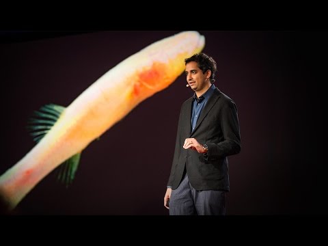
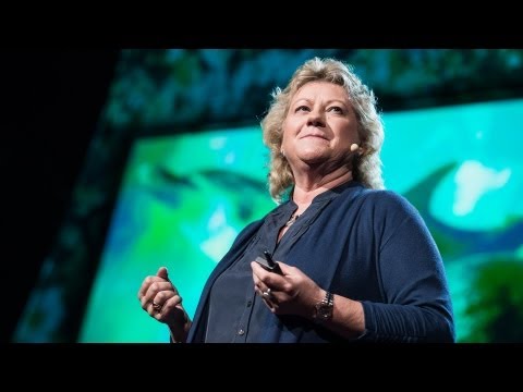
TED日本語 - セバスチャン・ド・ハルー: 風力ドローンによって海に対する私たちの考えが変わる
TED Talks
風力ドローンによって海に対する私たちの考えが変わる
How a fleet of wind-powered drones is changing our understanding of the ocean
セバスチャン・ド・ハルー
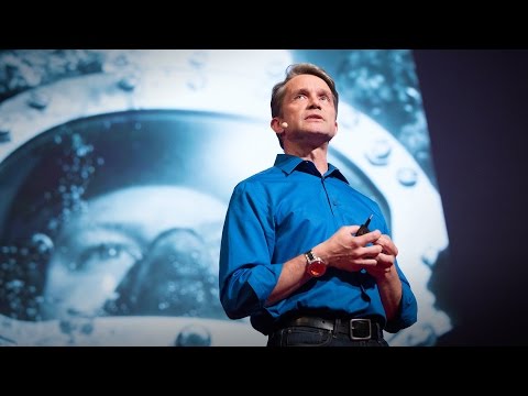
Sebastien de Halleux
内容
海は未開の場所で調査がほとんどされていません -- 今日、私たちは未だに地球よりも他の惑星についてよく知っているのです。どうしたら、この巨大で重要な生態系をよく知ることができるのでしょうか?探検家のセバスチャン・ド・ハルーは、風力と太陽光発電で動く新しいドローン部隊によって、今までなかった詳細な海のデータをいかにして集めるのかを説明します。そして、その集められたデータによって世界の気象や漁業資源の状態を知る手がかりが得られるのです。海をより理解することは陸での私たちの生活にも役に立つことでしょう。


字幕
SCRIPT
Script
We know more about other planets than our own, and today, I want to show you a new type of robot designed to help us better understand our own planet. It belongs to a category known in the oceanographic community as an unmanned surface vehicle, or USV. And it uses no fuel. Instead, it relies on wind power for propulsion. And yet, it can sail around the globe for months at a time. So I want to share with you why we built it, and what it means for you.
A few years ago, I was on a sailboat making its way across the Pacific, from San Francisco to Hawaii. I had just spent the past 10 years working nonstop, developing video games for hundreds of millions of users, and I wanted to take a step back and look at the big picture and get some much-needed thinking time. I was the navigator on board, and one evening, after a long session analyzing weather data and plotting our course, I came up on deck and saw this beautiful sunset. And a thought occurred to me: How much do we really know about our oceans? The Pacific was stretching all around me as far as the eye could see, and the waves were rocking our boat forcefully, a sort of constant reminder of its untold power. How much do we really know about our oceans? I decided to find out.
What I quickly learned is that we don't know very much. The first reason is just how vast oceans are, covering 70 percent of the planet, and yet we know they drive complex planetary systems like global weather, which affect all of us on a daily basis, sometimes dramatically. And yet, those activities are mostly invisible to us.
Ocean data is scarce by any standard. Back on land, I had grown used to accessing lots of sensors -- billions of them, actually. But at sea, in situ data is scarce and expensive. Why? Because it relies on a small number of ships and buoys. How small a number was actually a great surprise. Our National Oceanic and Atmospheric Administration, better known as NOAA, only has 16 ships, and there are less than 200 buoys offshore globally. It is easy to understand why: the oceans are an unforgiving place, and to collect in situ data, you need a big ship, capable of carrying a vast amount of fuel and large crews, costing hundreds of millions of dollars each, or, big buoys tethered to the ocean floor with a four-mile-long cable and weighted down by a set of train wheels, which is both dangerous to deploy and expensive to maintain.
What about satellites, you might ask? Well, satellites are fantastic, and they have taught us so much about the big picture over the past few decades. However, the problem with satellites is they can only see through one micron of the surface of the ocean. They have relatively poor spatial and temporal resolution, and their signal needs to be corrected for cloud cover and land effects and other factors.
So what is going on in the oceans? And what are we trying to measure? And how could a robot be of any use?
Let's zoom in on a small cube in the ocean. One of the key things we want to understand is the surface, because the surface, if you think about it, is the nexus of all air-sea interaction. It is the interface through which all energy and gases must flow. Our sun radiates energy, which is absorbed by oceans as heat and then partially released into the atmosphere. Gases in our atmosphere like CO2 get dissolved into our oceans. Actually, about 30 percent of all global CO2 gets absorbed. Plankton and microorganisms release oxygen into the atmosphere, so much so that every other breath you take comes from the ocean.
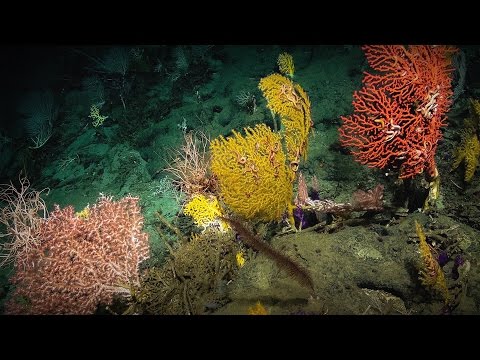
Some of that heat generates evaporation, which creates clouds and then eventually leads to precipitation. And pressure gradients create surface wind, which moves the moisture through the atmosphere. Some of the heat radiates down into the deep ocean and gets stored in different layers, the ocean acting as some kind of planetary-scale boiler to store all that energy, which later might be released in short-term events like hurricanes or long-term phenomena like El Nino. These layers can get mixed up by vertical upwelling currents or horizontal currents, which are key in transporting heat from the tropics to the poles. And of course, there is marine life, occupying the largest ecosystem in volume on the planet, from microorganisms to fish to marine mammals, like seals, dolphins and whales.
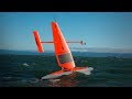
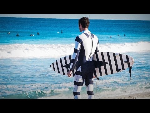
But all of these are mostly invisible to us. The challenge in studying those ocean variables at scale is one of energy, the energy that it takes to deploy sensors into the deep ocean. And of course, many solutions have been tried -- from wave-actuated devices to surface drifters to sun-powered electrical drives -- each with their own compromises. Our team breakthrough came from an unlikely source -- the pursuit of the world speed record in a wind-powered land yacht. It took 10 years of research and development to come up with a novel wing concept that only uses three watts of power to control and yet can propel a vehicle all around the globe with seemingly unlimited autonomy. By adapting this wing concept into a marine vehicle, we had the genesis of an ocean drone.
Now, these are larger than they appear. They are about 15 feet high,23 feet long,seven feet deep. Think of them as surface satellites. They're laden with an array of science-grade sensors that measure all key variables, both oceanographic and atmospheric, and a live satellite link transmits this high-resolution data back to shore in real time. Our team has been hard at work over the past few years, conducting missions in some of the toughest ocean conditions on the planet, from the Arctic to the tropical Pacific. We have sailed all the way to the polar ice shelf. We have sailed into Atlantic hurricanes. We have rounded Cape Horn, and we have slalomed between the oil rigs of the Gulf of Mexico. This is one tough robot.
Let me share with you recent work that we did around the Pribilof Islands. This is a small group of islands deep in the cold Bering Sea between the US and Russia. Now, the Bering Sea is the home of the walleye pollock, which is a whitefish you might not recognize, but you might likely have tasted if you enjoy fish sticks or surimi. Yes, surimi looks like crabmeat, but it's actually pollock. And the pollock fishery is the largest fishery in the nation, both in terms of value and volume -- about 3.1 billion pounds of fish caught every year.
So over the past few years, a fleet of ocean drones has been hard at work in the Bering Sea with the goal to help assess the size of the pollock fish stock. This helps improve the quota system that's used to manage the fishery and help prevent a collapse of the fish stock and protects this fragile ecosystem. Now, the drones survey the fishing ground using acoustics, i.e., a sonar. This sends a sound wave downwards, and then the reflection, the echo from the sound wave from the seabed or schools of fish, gives us an idea of what's happening below the surface. Our ocean drones are actually pretty good at this repetitive task, so they have been gridding the Bering Sea day in, day out.
Now, the Pribilof Islands are also the home of a large colony of fur seals. In the 1950s, there were about two million individuals in that colony. Sadly, these days, the population has rapidly declined. There's less than 50 percent of that number left, and the population continues to fall rapidly. So to understand why, our science partner at the National Marine Mammal Laboratory has fitted a GPS tag on some of the mother seals, glued to their furs. And this tag measures location and depth and also has a really cool little camera that's triggered by sudden acceleration. Here is a movie taken by an artistically inclined seal, giving us unprecedented insight into an underwater hunt deep in the Arctic, and the shot of this pollock prey just seconds before it gets devoured.
Now, doing work in the Arctic is very tough, even for a robot. They had to survive a snowstorm in August and interferences from bystanders -- that little spotted seal enjoying a ride.
(Laughter)
Now, the seal tags have recorded over 200,000 dives over the season, and upon a closer look, we get to see the individual seal tracks and the repetitive dives. We are on our way to decode what is really happening over that foraging ground, and it's quite beautiful. Once you superimpose the acoustic data collected by the drones, a picture starts to emerge. As the seals leave the islands and swim from left to right, they are observed to dive at a relatively shallow depth of about 20 meters, which the drone identifies is populated by small young pollock with low calorific content. The seals then swim much greater distance and start to dive deeper to a place where the drone identifies larger, more adult pollock, which are more nutritious as fish. Unfortunately, the calories expended by the mother seals to swim this extra distance don't leave them with enough energy to lactate their pups back on the island, leading to the population decline. Further, the drones identify that the water temperature around the island has significantly warmed. It might be one of the driving forces that's pushing the pollock north, and to spread in search of colder regions. So the data analysis is ongoing, but already we can see that some of the pieces of the puzzle from the fur seal mystery are coming into focus.
But if you look back at the big picture, we are mammals, too. And actually, the oceans provide up to 20 kilos of fish per human per year. As we deplete our fish stocks, what can we humans learn from the fur seal story? And beyond fish, the oceans affect all of us daily as they drive global weather systems, which affect things like global agricultural output or can lead to devastating destruction of lives and property through hurricanes, extreme heat and floods. Our oceans are pretty much unexplored and undersampled, and today, we still know more about other planets than our own.
But if you divide this vast ocean in six-by-six-degree squares, each about 400 miles long, you'd get about 1,000 such squares. So little by little, working with our partners, we are deploying one ocean drone in each of those boxes, the hope being that achieving planetary coverage will give us better insights into those planetary systems that affect humanity.
We have been using robots to study distant worlds in our solar system for a while now. Now it is time to quantify our own planet, because we can not fix what we can not measure, and we can not prepare for what we don't know.
Thank you.
(Applause)
私たちは地球のことよりも 他の惑星についてよく知っています だから今日は 地球のことを もっと知るために作られた 新しいタイプのロボットを紹介します 海洋学の分野では 無人水上艇 またはUSVと呼ばれる カテゴリーに属します このロボットは燃料を必要としません 代わりに風力で進みます それにもかかわらず 世界中を一度に何か月も航行できるのです 何故 このロボットを作ったのか どんな意味があるのかを ご説明しようと思います
数年前 サンフランシスコからハワイまで ヨットで横断していました それまでの10年間 何億というユーザーのために 休まずに働き ビデオゲームを開発してきました それで 現場から離れて 広く世界を知り 考える時間が欲しくなったのです 私は航海士でした 気象データを分析して航路を定めるという 骨の折れる仕事を終えた ある夕方に 甲板に出ると この美しい夕日を見たのです すると ある考えが浮かびました 私たちは海のことを 実際にはどれくらい知っているのか? 太平洋は私の周りに見渡す限り広がっていて 船は波によって大きく揺らされていました 海のはかり知れない力を 常に思い知らせるかのようでした 海について どの程度のことを 実際は知っているのだろうか? 私は調べて見ようと決心しました
すぐに分かったことは 私たちは海をよく知らないということです 第一の理由は正に海の大きさによるものです 地球の70%をも覆う広さです ただ 地球規模の複雑な現象が 海によるものだということはわかっています 例えば 誰もに毎日影響を与え 時には 劇的な影響及ぼす 地球全体の気象などです それなのに そういった現象について 私たちはほとんど知りません
海の情報はどう考えても少ないのです 陸について考えてみれば 多くのセンサーがあります 実際に何十億もです しかし海の場合は 現場データが不足し それに高価です 何故でしょう? 数少ない船やブイに頼っているからです その少なさには本当に驚きます NOAAとして知られている アメリカ海洋大気庁によれば 船はたったの16隻です ブイは世界中の沖に 200基未満しかありません 理由は簡単です 海の環境は非常に厳しいからです 現場データを収集するには 大量の燃料を運べて 多くの船員が乗れる 巨大な船が必要です 一隻につき何億ドルもかかります 海底へとつながる大きなブイは 4マイルの長さのケーブルを付けられ 重りとして列車の車輪が いくつか使われています 配備するのは危険ですし 維持するには多くのお金がかかります
衛星はどうなのかと思うかもしれません 衛星は素晴らしいです 数十年に渡って地球の全体像を 衛星によって把握してきました しかし衛星からでは 海面から1ミクロンまでの深さしか 観測できない項目もあります 衛星は時間的・空間的に 解像度が比較的低いです また 雲に覆われた部分や 陸の影響 その他の要素を 補正することが必要です
それでは海で何が起きているのでしょう? 何を計測したいのか? ロボットは何の役に立つのでしょう?
海の中の小さな一区画に着目します 私たちが知りたい 重要なものの一つは海面です 考えてみれば 海面には 空と海との相互作用が 全て集まっているのですから 全てのエネルギーや気体が 通り抜ける境界面です 太陽はエネルギーを放射します それは海に熱として吸収されます その一部は大気に放出されます 大気中のCO2のような気体は海に溶解します 実際に 世界中の約30%のCO2が 吸収されます プランクトンや微生物は 酸素を大気中に大量に放出するので 呼吸する酸素の半分は 海からくるほどです
海の熱は蒸気を生み それは雲になり やがてそれは降雨へとなります 気圧の勾配が地球表面の風を生み出し 大気中で水を移動させます 熱の一部は深海にまで届いて 異なる層に蓄積されます 海はまるで惑星規模のボイラーのように作用し 全ての熱エネルギーをため込み 短期的にはハリケーンや 長期的にはエルニーニョのような 気象現象を通じて放出されます 垂直上昇流または水平流によって これらの層は混合され 熱帯地帯から 北極・南極に熱を運ぶのに 重要な役割をします そしてもちろん 微生物や魚から アシカやイルカやクジラのような 海洋哺乳類に至るまでの 地球の最も大きな生態系を成す 海の生物がいます
海の生物のほとんどは 私たちには見えません そういった海を表す変数を 大規模に研究する際の課題の一つは エネルギーの問題です つまり 深海までセンサーを 配備するために使うエネルギーです もちろん様々な解決策が試されました 波を利用した装置から 海面を漂う装置や 太陽光発電を利用した電気装置ー 其々に妥協点があります 私たちのチームのブレイクスルーは 予期せぬ場所から生まれました ― 風力で動くランドヨットでの スピード世界記録を目指すチャレンジです 10年間に及ぶ研究開発により 限りなく自立性がありながら 制御するのにたった3ワットしか使わないのに 乗り物で世界中巡れるような 新しいコンセプトの翼形状を 考え出しました その翼のコンセプトを 海上の移動手段に適用することで 海上ドローンは始まりました
ドローンは見た目よりも大きく およそ 高さは4.5メートル 縦横は7×2メートルです 海面にある衛星と思ってください ドローンは海と大気に関する 主要な変数を全て計測する 精度の高いセンサー群を積んでいます そして 衛星通信により高解像度のデータを リアルタイムで陸地に送ります 私たちのチームは数年間に渡って 地球で最も厳しい海洋環境の中で この取り組みを熱心に 行ってきました 北極圏から熱帯太平洋に至るまでです はるばる極地の棚氷にまで行きました 大西洋のハリケーンの中にも行きました ホーン岬を回りました メキシコ湾の石油掘削装置の間を すり抜けてきました タフなロボットですね
最近 プリビロフ諸島のあたりで行った 私たちの仕事を紹介します プリビロフ諸島は アメリカとロシアの間のベーリング海にある 小さな島の集まりです ベーリング海はスケトウダラの故郷です スケトウダラは白身魚で ご存じないかもしれませんが もし魚のスティックやカニ風味かまぼこが 好きなら 食べたことがあるでしょう カニ肉のように見えますが 本当はスケトウダラです スケトウダラ漁は 国内で最大規模の漁業です 金額と量の両方の意味においてです ― 毎年 31億ポンドの水揚げ量があります
この数年間 何台かのドローンで ベーリング海で スケトウダラの漁業資源の 規模を調査しています この調査は漁場を管理して 漁業資源の枯渇を防ぐための クオータ制を改良するのに役立ち 損なわれやすい生態系を保護します 現在 ドローンは音響機器を使って 漁場の調査をしています すなわちソナーです ソナーは音波を下方に発信します そして 海底または魚群からの 音波の反響によって 海面下で何が起きているのかを 把握することができます 私たちの海洋ドローンは この反復調査にとても適しています ドローンは夜を日に継ぎ ベーリング海を調査しているのです
そして プリビロフ諸島は オットセイの群棲地でもあります 1950年 2百万頭のオットセイが 群棲地に暮らしていました 悲しいことに昨今 急激にその数は減少しています 元の数の50%未満しか 生き残っていません さらに 急激に減り続けています その原因を知るために 国立海洋哺乳類研究所の 研究パートナーが GPS機能のあるタグを 母オットセイの 身体に糊付けしました このタグにより位置と深さがわかります そして 急激な加速時に自動的に作動する 小さなカメラを搭載しています これは北極の深い海の中での 狩りの様子を知ることのできる ― 芸術的な狩りの動きをする オットセイと 餌となるスケトウダラの映像です これは捕食される瞬間のほんの数秒前です
ロボットとはいえ 北極圏での作業は厳しいです 8月にも 吹雪を耐え忍んだり 思わぬ訪問者による妨害を 我慢したりしなければいけません ― 小さなゴマフアザラシが 乗っかって遊んでいます
(笑)
オットセイのタグはシーズンを通して 20万回以上の潜水の映像を撮影しています よく観察してみると オットセイの行動経路と 繰り返しの潜水がわかりました 私たちは狩り場で実際に何が起きているのかを 解明しようとしています 見事なものですよ ドローンによって集められた 音響データを重ね合わせてみると その実像がわかりはじめます オットセイが島から離れて 縦横無尽に泳ぎ回るときに 深さ20メートルくらいの比較的浅い場所で 泳いでいることが観察されています ドローンの調査によれば カロリーの低い 小さなスケトウダラが 多くいる場所です そしてオットセイは もっと遠くて深いところまで潜ります そこはドローンの調査によれば より栄養価の高い魚である 大きなスケトウダラがいる場所です 残念ながら より遠くまで泳ぐために 母親のオットセイは カロリーを使ってしまうので 陸に戻ってから子供に乳を与えるのに 十分なエネルギーは残されていません そのために群れの頭数は 減少してしまうのです さらに ドローンは島の周りの水温が 著しく上昇していることを 発見しました その水温の上昇によってスケトウダラは さらに温度の低い場所を求めて 北方に追いやられているのかもしれません データは解析中ですが 次第にオットセイの神秘のパズルが 解けてきていることは すでに分かっています
しかし 大きな視点から見直してみれば 私たちも哺乳類なのです そして実際に 海は人間一人あたり 毎年20kgの魚を供給しています 漁業資源が激減する中で 私たちはオットセイの物語から 何を学ぶことができるのでしょう? 魚の問題だけではありません 世界の穀物生産量に影響を与え 生命や財産に甚大な被害をもたらしうる ハリケーンや猛暑 それに洪水を引き起こす ― 世界の気象系を海は動かしているので 私たち全員に毎日影響を及ぼすのです 海は未開の場所で 調査がほとんどされていません 今日 私たちは未だに他の惑星のことを 地球よりもよく知っているのです
しかし もしこの広大な海を 一辺が経度緯度6度の正方形で分割すれば だいたい各辺が640kmになります 1000くらいの正方形ができるでしょう だから少しづつパートナーと協力して 私たちはその四角一つに対して一つの 海上ドローンを配備しています そうやって地球全体を カバーすることによって 人類に影響を与える地球のシステムを 理解する手掛かりが 得られると期待します
今までしばらくの間 太陽系の離れた世界を ロボットを使って 調査してきました 今こそ 地球を計測するときなのです なぜなら私たちは計測できないものを 修理することはできませんし 知らないことに対して 準備することはできないのですから
以上です
(拍手)
品詞分類
- 主語
- 動詞
- 助動詞
- 準動詞
- 関係詞等
TED 日本語
TED Talks
関連動画

騒がしい海の危険性―海をどのように静かできるのかニコラ・ジョーンズ
2020.04.16オオジャコガイの知られざる魅惑的生態メイ・リン・ネオ
2017.10.12なぜサンゴ礁にはまだ希望があるのかクリステン・マーハバー
2017.08.11盲目の洞窟魚に見る先史時代へのヒントプロサンタ・チャクラバーティ
2016.08.09神秘的な海底で私が出会う秘密ローラ・ロビンソン
2016.03.30海洋写真家の世界へ飛び込もうトーマス・ペスチャック
2016.03.21暗闇で光るサメと驚くほど美しい海洋生物たちデビッド・グルーバー
2016.02.16生命で輝きを増す海中美術館ジェイソン・デカイレス・テイラー
2016.01.22幼生サンゴを育ててサンゴ礁を再生するには?クリステン・マーハバー
2015.12.23なぜ鯨の糞が大切なのかアーシャ・デ・ボス
2015.01.05水中で31日間を過ごして学んだことファビアン・クストー
2014.10.23サメ除けウェットスーツ(あなたの想像とは違います)ハミッシュ・ジョリー
2014.04.23ヒトはイルカの言葉を話せるだろうか?デニーズ・ハージング
2013.06.06いかにして巨大イカを見つけたかエディス・ウィダー
2013.03.05海洋生物調査ポール・スネルグローブ
2012.02.28タコに魅せられてマイク・ディグリー
2012.02.05


洋楽 おすすめ
RECOMMENDS
洋楽歌詞
ダイナマイトビーティーエス
洋楽最新ヒット2020.08.20ディス・イズ・ミーグレイテスト・ショーマン・キャスト
洋楽人気動画2018.01.11グッド・ライフGイージー、ケラーニ
洋楽人気動画2017.01.27ホワット・ドゥ・ユー・ミーン?ジャスティン・ビーバー
洋楽人気動画2015.08.28ファイト・ソングレイチェル・プラッテン
洋楽人気動画2015.05.19ラヴ・ミー・ライク・ユー・ドゥエリー・ゴールディング
洋楽人気動画2015.01.22アップタウン・ファンクブルーノ・マーズ、マーク・ロンソン
洋楽人気動画2014.11.20ブレイク・フリーアリアナ・グランデ
洋楽人気動画2014.08.12ハッピーファレル・ウィリアムス
ポップス2014.01.08カウンティング・スターズワンリパブリック
ロック2013.05.31ア・サウザンド・イヤーズクリスティーナ・ペリー
洋楽人気動画2011.10.26ユー・レイズ・ミー・アップケルティック・ウーマン
洋楽人気動画2008.05.30ルーズ・ユアセルフエミネム
洋楽人気動画2008.02.21ドント・ノー・ホワイノラ・ジョーンズ
洋楽人気動画2008.02.15オンリー・タイムエンヤ
洋楽人気動画2007.10.03ミス・ア・シングエアロスミス
ロック2007.08.18タイム・トゥ・セイ・グッバイサラ・ブライトマン
洋楽人気動画2007.06.08シェイプ・オブ・マイ・ハートスティング
洋楽人気動画2007.03.18ウィ・アー・ザ・ワールド(U.S.A. フォー・アフリカ)マイケル・ジャクソン
洋楽人気動画2006.05.14ホテル・カリフォルニアイーグルス
ロック2005.07.06